- Eruptions: Where It's Always Volcano Day
- Posts
- Eruptions Newsletter #23 for November 21, 2025
Eruptions Newsletter #23 for November 21, 2025
We're back in more ways than one with news from Semeru in Indonesia, the latest eruptions at Kīlauea and the viral malfunctioning seismometer at Mount Rainier.
Erik Klemetti
November 21, 2025
Sorry about the extra week in-between newsletters. November does tend to spawn a monster when it comes to schools on a semester schedule.
Thankfully, the US government closure ended, so we’ve for the Global Volcanism Program’s reports back, as well as the USGS back to full steam. Hopefully this doesn’t happen again in January 2026.
Activity News
Semeru, Indonesia

Capture from a livestream of the eruption of Semeru on November 19 showing the pyroclastic flows from the volcano.
There is some impressive video of the latest activity at Semeru in Indonesia. The volcano on the island of Java produced some large pyroclastic flows that travelled up to 7 kilometres from the volcano on November 19. The local authorities have raised the alert status near the volcano to the highest level and restricted people from getting closer than ~2.5 kilometres to Semeru. So far, there aren’t any reports of casualties from the eruption, but 900 people have been evacuated to shelters and 170 climbers on the mountain had to be rescued from their camp. Some of the unverified videos show heavy ash fall in areas close to Semeru.
Ash from these new blasts reached as high as ~18,000 feet (5.6 kilometres), but it is really the pyroclastic flows that merit notice here. These flows move fast (100s km/hr), hot (>300C) and are highly destructive. Not to downplay ash fall, but when pyroclastic flows are involved, you need to act fast. All this ash means potential flight disruptions in the area as well.
Earlier in the month, there were some smaller explosions from the summit of the volcano near what looks like a growing lava dome. Video from November 1 very clearly shows the crumbling of part of the summit lava dome and small pyroclastic flows were caught on video on November 17. On November 7, rainstorms also caused lahars (volcanic mudflows) from Semeru as well and this video shows the lahar approaching in the river valley near the volcano. The closeup is both amazing and startling at the same time — and you can see the webcam vibrating as the lahar moves past.
If you watch the video of the eruption (note: it is sped up), what is most striking is the waves of pyroclastic flows that rush out from the volcano. The edifice itself is shrouded in clouds and ash, but the billowing fronts of the flows are clearly seen. They are tall! Compare the height of the clouds to the trees. In a few spots in the video you can see the damage to the forests near the volcano as well as grey ash coating the trees (see below).

Close up of an area damaged by pyroclastic flows from Semeru taken from a livestream of the eruption on November 19.
Semeru is no stranger to deadly pyroclastic flows. As recently as December 2021, 62 people died during an eruption with such flows. The steep sides of the volcano and the propensity to erupt lava domes that can collapse, leading to explosive eruptions, make it especially hazardous. Over 1 million people live within 30 kilometres of Semeru.
Kīlauea, Hawai’i
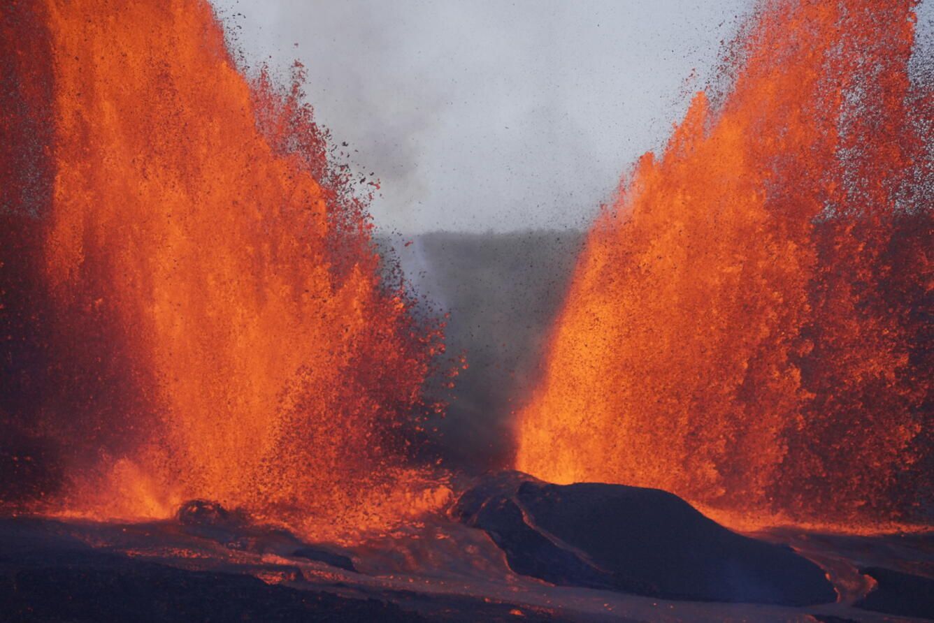
Telephoto shot of the twin lava fountains during the November 9 eruption of Kīlauea. Credit: Matt Patrick/USGS
About a week after the last edition of this newsletter went out, Kīlauea had yet another summit eruption. This time, spectacular twin lava fountains erupted for ~5 hours on November 9 (see above). The latest update forecasts that the next eruption may occur between November 21 (hey, that’s today!) and 25 based on inflation rates at the summit of Kīlauea.
Now that the US government shutdown is over, the Hawaiian Volcano Observatory posted a collection of images and videos from the 3 eruptive episodes that occurred during the closure. The 35th eruptive episode in mid-October was so intense that the webcam located closest to the vents suffered some heat damage. That same episode produced the tallest lava fountains seen this year, reaching 450 meters (1,475 feet).
HVO also posted some fascinating images showing the damage to infrastructure in the National Park downwind of the current eruptions. This includes some buried (and melted) plastic road markers, impressive cracks that have formed across the crater rim road and wooden posts that have been charred. All of this is in an area currently closed off to any public access.
Volcano Word of the Week
This week’s volcano word is lahar. This month marks the 40th anniversary of one of the deadliest lahars in history, the 1985 disaster at Nevado del Ruiz in Colombia that buried Armero. Lahars, also called volcanic mudflows, can sometimes be underestimated in terms of their destructive power. They can appear just like muddy water and lack the heat and speed of pyroclastic flows. However, they make up for that with an intensity and relentlessness that can bury towns, roads, bridges and people.
Many volcanoes are not put together particularly well. Your average volcano in a place like the Andes, Indonesia or the Cascades is made of layers of loosely consolidated material like ash and lavas like a layer cake.
They also can be homes to copious amounts of water, usually in the form of snow, ice or crater lakes. In many areas, they can also experience heavy rains from storms. If any eruption occurs and melts the snow/ice on the volcano or breaches the walls of the crater lake or even just happened when there is a lot of rain, you have the potential for a mudflow.
If you take a lot of water and mix it with the loose debris, it makes a slurry much like wet cement (depending on the proportions) and this material will travel downslope in stream channels. Because it is so concentrated in volcanic debris, it has a lot of strength (unlike water), so it will be able to pick up, carry or push out of the way large objects like boulders, trees, trucks, houses and more.
Once the lahar leaves the river channel onto a floodplain where the slopes flatten, the slurry will stop moving and bury whatever is at the lowest levels near the stream channel. If that’s not bad enough, once it stops moving, the lahar will “dewater”, meaning that the water between all the debris will separate as the debris settles out, leaving more water to flood the area. The settled debris will then become a cohesive mass that does more-or-less act like concrete, entombing whatever it buried.
Lahars can be devastating for low-lying areas near stream channels leading off of volcanoes. However, unlike pyroclastic flows, lahars tend to stick to the bottoms of stream channels. They also move much slower, usually at speeds of tens of kilometres per hour rather than the 100s km/hr that pyroclastic flows move. The upshot is that with sufficient warning on the flanks of volcanoes, you can make a plan to escape being buried by a lahar.
Places like Mount Rainier have lahar early warning networks that involve trips and cameras to detect lahars as they start high up on the volcano. This signal gets sent to communities downslope that might then have hours to get people to higher ground away from the stream or river channel.
These early warning networks are the direct product of the tragedy at Nevado del Ruiz in 1985. In that case, the threat of potential lahars at Ruiz was high, but there was no clear system to warn people when a lahar might be coming. A small eruption triggered a lahar, but the word did not get spread widely in Armero, so when the lahar emptied out of the Rio Lagunilla gorge almost 50 kilometres (as the crow flies) from the eruption, people were caught off guard and were buried. Over 20,000 people died.
I have a memory of driving in the area of Armero when I was a kid a few years after the tragedy. My mother grew up in Pereira, about an equal distance from the volcano as Armero but on the other side. The odd stream valleys that looked like someone had filled them with cement stand out in my memories.
Odds & Ends
In the realm of “why we can’t have nice things”, internet rumours claimed that Mount Rainier was headed towards an eruption. Guess what? It clearly isn’t true. Instead, the Pacific Northwest Seismic Network (PNSN) says that the seismometer that got people all hot and bothered was just malfunctioning. None of the other seismometers near Rainier showed anything anomalous — and that should be the first clue that this isn’t a signal to a volcano waking up, but rather something wonky with an instrument.
This does bring up the continuing problem of people with some knowledge (sometimes bordering on no knowledge) attempting to interpret publicly available scientific data such as webicorder traces from seismometers at volcanoes. More than once, something benign like a malfunction, wind, cars or more have been swept up by someone on the internet and turned into a dire forecast of doom. Then, unscrupulous media runs with it to make these rumours seem even more legitimate.
So, good rule of thumb: don’t believe amateur speculations about volcanic unrest. Wait to see what response official groups like the PNSN, USGS or whatever you may have has to say. That’ll make life easier for all of us.
Sounds of the Week
Nick Hornby, in his book Songbook, says that songs get stuck in our heads because our brains are trying to “solve” them. If that is the case, I’ve been trying to solve this one all week:
Questions? Comments? Thoughts? Feel free to leave a comment, send me a note or follow me on Bluesky (@erikklemetti.bsky.social).
Be sure to check out my podcast, 5 Minute Volcano and the Patreon page for the Eruptions Newsletter/5 Minute Volcano Podcast.
Reply